Construction of the Great Dune of Pyla (history)
Construction of the Great Dune of Pyla (History).
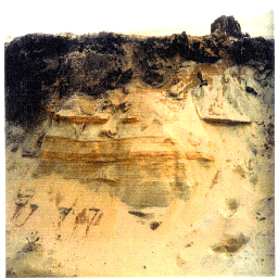
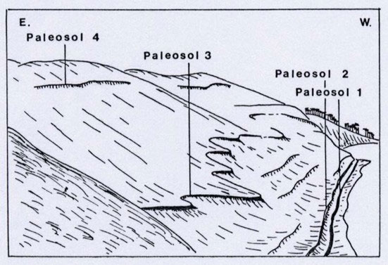 Dark lines, especially visible in winter, when the crowd shuffling through the dune is lesser, can be observed on the western side. These dark lines correspond to old soils (paleosols) which make it possible to reconstruct the history of this great dune. From base to summit, you can discover 4 main paleosols on the western slope: an old podzol (paleosol 1) and 3 dune paleosols (paleosol 2, 3 and 4) plus many minor paleosols, whose lake deposits and heavy mineral beds. The dates are indicated by radiocarbon ages (Froidefond et Legigan, 1985), palynologic analysis (Paquereau et Prenant, 1961) and historic dating (Dautant et al., 1983).
-Paleosol 1. The base of the dune (at the beach level) is underlined by an old podzol (stratified soil in which various materials have been leached from the upper layer and redeposited in a well-defined lower stratum). The upper layer is constituted of vegetables (peat) forming an impermeable layer. You can see on this old ground, some stumps of pine. The radiocarbon ages indicate the date of the burial by sand dunes, since about 3500 years ago (3680 ± 110 years B.P. and 3460 ± 70 years B.P.) Palynologic analysis shows that the forest cover was constituted of sylvan pines (Pinus silvestris), oaks, hazels, birches and alders. No sign of human occupation was observed at the surface of this ground.
The base of the dune (at the beach level) is underlined by an old podzol (stratified soil in which various materials have been leached from the upper layer and redeposited in a well-defined lower stratum). The upper layer is constituted of vegetables (peat) forming an impermeable layer. You can see on this old ground, some stumps of pine. The radiocarbon ages indicate the date of the burial by sand dunes, since about 3500 years ago (3680 ± 110 years B.P. and 3460 ± 70 years B.P.) Palynologic analysis shows that the forest cover was constituted of sylvan pines (), oaks, hazels, birches and alders. No sign of human occupation was observed at the surface of this ground.
-Paleosol 2. This one is located between 2 and 5m above sea-level. The radiocarbon ages – 2980 ± 110 years B.P., 2690 ± 70 years B.P. are confirmed by some tools (fragments of pottery) dating from the middle Bronze age (VIIth century B.C.). A protruding vase, decorated with four fluting underlined with a row of slanting incisions and an earthenware fusaiole were discovered at some meters above, in January 1982 by Ph Jacques (Bull. N°36, S.H.A.A., 1983). The paleosol 2 contains a blending of Pinus Pinea (maritime pine) and Pinus Silvestris pollens.
This one is located between 2 and 5m above sea-level. The radiocarbon ages – 2980 110 years B.P., 2690 70 years B.P. are confirmed by some tools (fragments of pottery) dating from the middle Bronze age (VIIth century B.C.). A protruding vase, decorated with four fluting underlined with a row of slanting incisions and an earthenware fusaiole were discovered at some meters above, in January 1982 by Ph Jacques (Bull. N°36, S.H.A.A., 1983). The paleosol 2 contains a blending of (maritime pine) and pollens.
- Intermediate paleosols and layer of diatoms. Above paleosol 2, about 20m above sea-level, appear 2 to 4 thin layers. Some are composed of vegetation remains (dune paleosols), and others by layers of siliceous fresh water diatoms (white levels). These diatoms were transported by wind, probably from a pond or a lake located in the vicinity. The inventory of diatoms carried out by Mr M. Coste (Froidefond and Legigan, 1985) show that the species (Pinnularia, Epithemia, Rhopalodia, etc…) lived in a permanent lake.
Above paleosol 2, about 20m above sea-level, appear 2 to 4 thin layers. Some are composed of vegetation remains (dune paleosols), and others by layers of siliceous fresh water diatoms (white levels). These diatoms were transported by wind, probably from a pond or a lake located in the vicinity. The inventory of diatoms carried out by Mr M. Coste (Froidefond and Legigan, 1985) show that the species (Pinnularia, Epithemia, Rhopalodia, etc…) lived in a permanent lake.
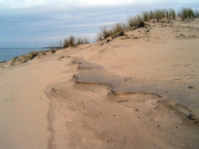 - Intermediate paleosols and layer of diatoms. Above paleosol 2, about 20m above sea-level, appear 2 to 4 thin layers. Some are composed of vegetation remains (dune paleosols), and others by layers of siliceous fresh water diatoms (white levels). These diatoms were transported by wind, probably from a pond or a lake located in the vicinity. The inventory of diatoms carried out by Mr M. Coste (Froidefond and Legigan, 1985) show that the species (Pinnularia, Epithemia, Rhopalodia, etc…) lived in a permanent lake.
Above paleosol 2, about 20m above sea-level, appear 2 to 4 thin layers. Some are composed of vegetation remains (dune paleosols), and others by layers of siliceous fresh water diatoms (white levels). These diatoms were transported by wind, probably from a pond or a lake located in the vicinity. The inventory of diatoms carried out by Mr M. Coste (Froidefond and Legigan, 1985) show that the species (Pinnularia, Epithemia, Rhopalodia, etc…) lived in a permanent lake.
- Paleosol 3. The altitude of this paleosol varies from 20 to 40m. From the morphology and the altitude, this one corresponds to the upper part of parabolic dunes, located just to the East. On this surface – a dark ground -, we have discovered old bronze coins dating from the XVIth century, accumulations of fragments of shells, a resin furnace…
The altitude of this paleosol varies from 20 to 40m. From the morphology and the altitude, this one corresponds to the upper part of parabolic dunes, located just to the East. On this surface – a dark ground -, we have discovered old bronze coins dating from the XVIth century, accumulations of fragments of shells, a resin furnace…
- Paleosol 4. Paleosol 4 represents the surface of the “Dune de La Grave” mapped in 1863. The “Dune de La Grave” was a transverse dune reaching 80m in height. This dune was covered by a pine forest planted during the XIXth century to stabilize the Aeolian sands, to exploit the wood and to produce pine resin (collected in earthenware pots) for industrial use. Paleosol 4 was subsequently buried by 20 to 30m of Aeolian sands derived from the West which formed the Great Dune of Pyla by the beginning of the XXth century.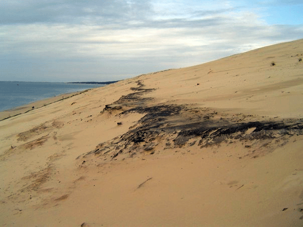
Paleosol 4 represents the surface of the “Dune de La Grave” mapped in 1863. The “Dune de La Grave” was a transverse dune reaching 80m in height. This dune was covered by a pine forest planted during the XIXth century to stabilize the Aeolian sands, to exploit the wood and to produce pine resin (collected in earthenware pots) for industrial use. Paleosol 4 was subsequently buried by 20 to 30m of Aeolian sands derived from the West which formed the Great Dune of Pyla by the beginning of the XXth century.
Construction of the Great Dune of Pyla.
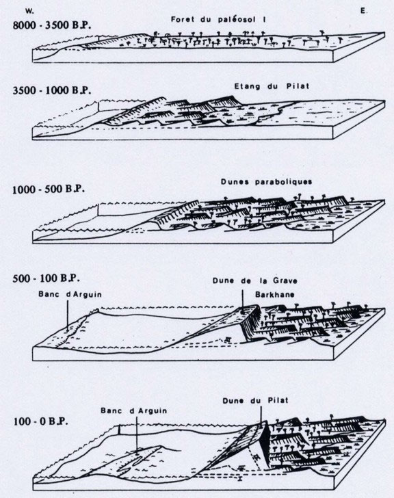
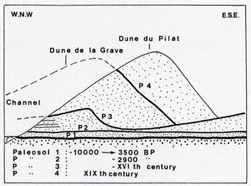 This is a recent dune built on parabolic dunes after the XVIIIth century and essentially at the end of the XIXth century by accumulation of Aeolian sands on a transverse dune, the “Dune de la Grave”. This local construction of sand has been generated by the displacement of the Arcachon Bay South Channel toward the southeast. The channel migration instigated severe erosion on the eastern shore, at the base of the Great Dune.
Between 1826 and 1922, the Pyla coast has been eroded of about 500m. The vegetation covering the West side of the “Dune de La Grave” was destroyed. Without vegetation, the sands were transported by the wind toward the summit and deposited on the young pines and on the lee side (M.Clavel, 1887).
Ce message est également disponible en : French
