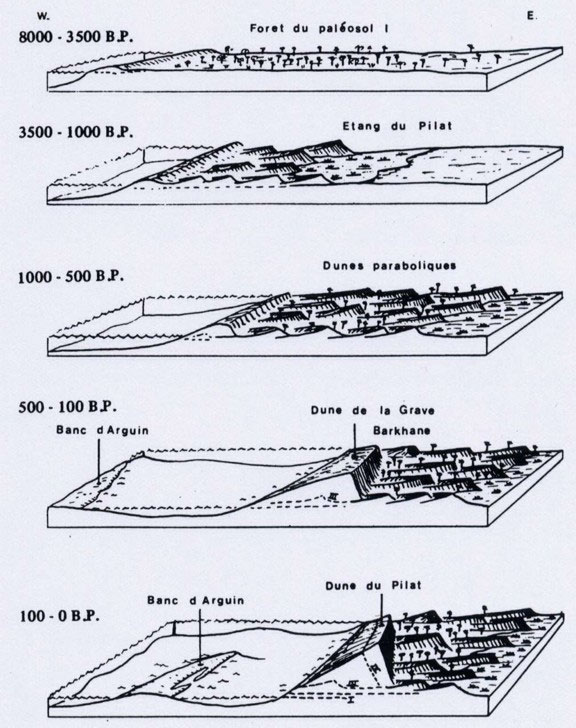
The present displacement of the Great Dune of Pyla.
The progression of the Great Dune from maps.
Superimposing maps of the French Geographical Institute (I.G.N.) dating 1966 and 1989, a global displacement appears clearly. This one is between 70m and 100m following from North to South respectively, that gives an annual displacement of 3m to 4.3m. So the dune progresses on the pine forest.
Measurements obtained by Mr Henri Ferradou since 1935
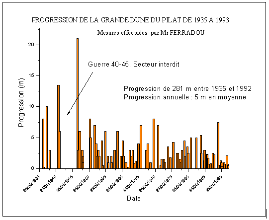
Mr Ferradou has measured the displacement toward the East of the Great Dune, between 1935 and 1992, in other words, the inland progression to the detriment of the pine forest. These measurements have been carried out, using characteristic pines. For instance, on September 13, 1935, he chosen a young pine of 3m height sloping above a path and he tied a ribbon around 2m high. Then he measured the distance between the foot of the tree and the foot of the East side of the dune. The results obtained, give a global displacement of the south part of 280m during 57 years that is a mean of 4.9m / year. This result is comparable to the mapping measurements. The migration of the dune is discontinuous, sometimes fast (10m between 1936 and 1937; 7m between 1965 and 1966, 7m between 1970 and 1971; 7.5m between 1988 and 1989, for example) and sometimes, very slow (0m between 1961 and 1962 for example) as showed on the following diagram from the measurements of Mr Ferradou.
This migration of the Great Dune has covered private plots of forest. The Great Dune overlaps about twenty private properties. Each year, the sand of the east slope of the dune covers 8000m2 of forest. At the North East part of the dune, a road was overlapped in 1987 after an avalanche of sand, and buried in 1991. The example of a house buried over the dune is cited in a newspaper “L’Illustration”, paper written by Ricaudy in September, 19, 1936. At the South East of the dune, where was a glade, inhabitants of Bordeaux decided to have a villa built in 1928. Two years after in 1930, the sands began to invade the house in spite of the efforts of the occupiers. The house has completely disappeared over the sands in 1936.
This progression toward East coincides with important marine erosion at the foot of the west side of this dune. From 1863 to 1989, the coastline is moved more than 1km toward East (7.5 to 8m/year). This erosion was more important to the South than the North. Besides, a small airfield existed, to the West of the “La Corniche” Hotel (Hotel Oyana), which has completely disappeared, replaced by the South Channel of the Bay.
In about forty years, if the progression of the dune goes on at the same speed, the Biscarrosse road and the camping located at the foot of the slope will be buried under the sands.
Ce message est également disponible en : French


